Photo courtesy of the U.S. Army Corps of Engineers, New York District
To reduce such massive flooding in the future, USACE is performing several coastal flood risk management projects like the Union Beach effort, all of which are partially funded by the Hurricane Sandy Disaster Relief Appropriation Act of 2013, or what is referred to as the 'Sandy Bill.'
The autumn of 2012 saw Superstorm Sandy devastate the East Coast of the United States with the hardest hit areas being New York City and northern New Jersey.
Firefighter Paul Kerwin clearly recalled the day he and his company rescued their fellow Union Beach, N.J., neighbors.
"Sandy was quite an experience. We worked around the clock pulling people out from their flooded homes that were submerged in almost 10 feet of water," he said. "I remember a house actually coming off its foundation and floating across a creek, and a shed lifting off the ground and drifting down a road with a man standing on its roof. We saved him and did about 200 [other] rescues that night."
As a lifelong resident of the borough and a veteran firefighter with the Union Beach Gardens Fire Department, the safety of his community is of paramount importance to him. It extends to his other job, too, as a maintenance worker of the New Jersey Department of Environmental Protection (NJDEP).
Now, the state agency is working in collaboration with the U.S. Army Corps of Engineers (USACE), New York District on coastal restoration projects along the New Jersey coast that will help to reduce flooding from both future Sandy-like storms and sea level rise, with the hope of putting an end to the days when he has to rescue his neighbors from atop their roofs.
One of these efforts is the Union Beach New Jersey Coastal Storm Risk Management Project.
Union Beach is a 1.8-sq.-mi. bayside community along the coast of Raritan Bay on the northern portion of Monmouth County that offers its residents and visitors a spectacular view of the New York City skyline and the Verrazano-Narrows Bridge.
Over the years, the community's residential and commercial waterfront has experienced flooding during tidal coastal storms due to its location on low-lying land surrounded by several small creeks. The flooding has worsened due to an increase in tidal storm events, restricted the creeks' channel flow, and increased urbanization and coastal erosion.
As a result, when Superstorm Sandy blew across the region, Union Beach was devastated. Storm surge flooded 90 percent of the borough, 60 structures were destroyed, and another 629 were substantially damaged, leaving behind 4,500 tons of debris.
To reduce such massive flooding in the future, USACE is performing several coastal flood risk management projects like the Union Beach effort, all of which are partially funded by the Hurricane Sandy Disaster Relief Appropriation Act of 2013, or what is referred to as the "Sandy Bill."
USACE is performing the work in collaboration with NJDEP, its non-federal sponsor, and Weeks Marine, based in nearby Cranford, N.J.
"We're excited to be working on this project because Union Beach has been battered by many storms that have included a nor'easter in 1992, Superstorm Sandy and most recently Tropical Storm Ida in 2021," noted David Gentile, a project manager of the USACE.
He said the construction is designed specifically to create a line of defense around the Union Beach community to help reduce flooding during future storms. This includes increasing the size of the shoreline, installing measures that will slow beach erosion and building inland structures that will help keep tidal water and rainwater out of the line of defense.
Thousands of Tons of Beach Sand Pumped In
Union Beach has eroded over the years due to wave action and longshore currents. When hurricanes and coastal storms occur, breaking waves and elevated water levels can change the width and elevation of beaches and accelerate erosion, which can put community structures landward of the beach in jeopardy.
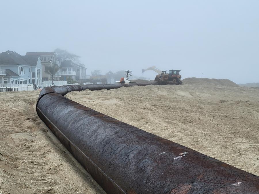
To help protect the community, the USACE is dredging more than 600,000 cu. yds. of ocean sand and pumping it onto the beach to increase the beach's height and width. In addition, a 16- to 18-ft.-high dune will be built and planted with dune grass.
In addition, the federal agency said that an enlarged beach and dunes system will act as a buffer between the waves and storm water levels and communities near the shore, something demonstrated during Superstorm Sandy.
After the storm fizzled out, the USACE examined its beach restoration projects across the Northeast to identify what projects were more effective in reducing storm risk to shore communities. The analysis showed that beach towns that had previously received shore restoration and dune construction sustained less destruction and saved billions of dollars in avoided damages.
USACE Installing Series of Protection Structures
To slow the erosion of the newly constructed Union Beach, construction will be done to install two groins — structures that extend perpendicular from the shore into the water to interrupt water flow and limit the movement of sand — to prevent beach erosion.
Inland from the beach, other structures will be built that will reduce flooding and help the storm water system drain excess water without allowing tidal water to flood the community.
The small waterways found at Union Beach that tend to flood during heavy storms are Chingarora Creek, Flat Creek, and East Creek, where the USACE is constructing three pumping stations and two sluice gates to diminish the risk of tidal flooding. Pump stations allow water to be removed from within the line of defense while the sluice gates are closed to prevent tide flood waters from overwhelming a community.
Several levees and flood walls also are planned for construction to keep tidal water from entering Union Beach.
As of Jan. 10, the federal agency said that most of the beach construction had been completed and the remainder of the Union Beach project will be finished later in 2024.
In addition, Col. Alexander Young, commander of the USACE's New York District, said in a news release that his crews have completed 52 of the 60 projects in the district's Superstorm Sandy Coastal Storm Risk Reduction program.
Today's top stories


